Sunday, 29 January 2023
And more kitty photos:
.JPG) |
| These are both of Bucky. |
.JPG) |
| Looks comfy, doesn't he? |
Before we left the campground, I spent some time online and on the phone trying to find propane. I'd hoped this campground had some but apparently not. The only town of real size I'd planned to go through today was Okeechobee, and with today a Sunday and this town having fewer than 6,000 residents, I wasn't surprised when I couldn't find any. But we were almost down to empty and I didn't want to get stuck wanting it and not having it.
I finally found a Tractor Supply there and called them, but they had it only in portable bottles. But when I asked if they knew anybody who could help me, they suggested Garrard's Tackle Shop near them. Propane at a tackle shop? I called Garrard's and they sure, come on down.
.JPG) |
| today's route |
I passed through the town of Sebring, which seemed very spread out. I learned online that it doesn't have a Main Street because it entirely encloses Lake Jackson, which is a pretty good sized lake. A sign told me it was the Home of the 12 Hour Grand Prix. This is where the Sebring International Raceway is located, a track that was first used in 1950 and, with many modifications, is still in use. It's considered an important site for preparing for the Le Mans race in France.
I passed a house flying a Confederate flag flanked by 2 flags, both with 3 stripes of pink, black and blue. I looked online but can't find anything that looks like that.
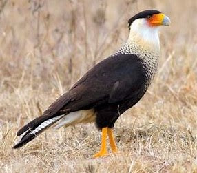 |
| Crested Caracara |
 |
| Osprey |
According to the bird book, just about the only ones that seem the right size and might be interested in a nest in this area and have a lot of black and white are these two. Oddly, the Caracara is in Florida only in this area and is here year round. The Osprey is in the whole state year round. Whatever they were, it was exciting to see such big birds so near the road.
I crossed the Kissimmee River, which flows from near Orlando, creates Lake Okeechobee, then continues south to become the northern wetlands area of the Everglades. It's a busy little river.
And then we came to the town of Okeechobee at the northern end of the lake. I stopped here first because Dext wanted a walk, and we saw a nice park in the middle of the downtown. The main feature of that park was a series of sculptures of a cattle drive.
.JPG)
.JPG)
Here are the explanatory plaques about these.
.JPG)
.JPG)
.JPG) |
Across the street was a different kind of artwork.
.JPG)
We stopped in town for groceries and gasoline ($3.59/gallon), and then I went looking for Garrard's Tackle Shop. And had to wait in line behind other folks wanting propane. But I was glad to get it and I didn't ask why a tackle shop would be the only place in town selling it.
Just outside of town I saw a sign for Okeechobee Battlefield State Park. I didn't go but looked it up - and had a surprisingly hard time finding out what it was about. Close to 1,000 US troops fought about 400 Seminole warriors. Both sides claimed victory, though based on casualties, I'd say the Seminole won. If you're interested, here's the clearest account I could find. https://en.wikipedia.org/Battle-of-Lake-Okeechobee
Another battle is still apparently being fought in these parts: I saw 2 more Confederate flags along the way.
The main thing I wanted to do today was take a look at Lake Okeechobee. It's the largest freshwater lake in Florida, the 10th largest natural freshwater lake in the US, and follows only Lake Michigan for being largest natural freshwater lake that's entirely within the Lower 48 states. It's too large to see across - per Wikipedia, but also per me - I couldn't see to the other side at one of those wide points. The lake is surrounded by a dike, which meant I couldn't get good views of it for much of my drive. But the dike is apparently often used as a hike and bike path.
All along the road beside the lake I passed RV parks - people who came for the fishing and people who figured this was a good place to retire.
I saw bougainvillea blooming.
I passed a bar that was thick with bikers, according to the number of them parked outside. Today was certainly a good day for a ride.
The Intracoastal Waterway flows through Lake Okeechobee beginning at Port Mayaca, where I got a view of the lake that looked so big it was like an ocean bay.
The post office at Pahokee is orchid colored.
I saw what I thought was a sea of sea oats or some such plant. But now I think what I saw was sugar cane. I was thrown off by the plants only being 3'-4' tall, but if the cane was harvested and replanted a few months ago, it would likely be about this height now. Florida produces 52% of US sugar cane by value. I had no idea, though Gail and Dem mentioned it yesterday, which was my head's-up.
A sign told me to watch out for tractors.
In South Bay, we found John Stretch Park which was a very pleasant and very popular little picnic area by the road. There were a couple dozen picnic tables and shelters around a little pond, full of families and couples enjoying a sunny Sunday afternoon. I saw one enterprising young woman who was asleep in a hammock she'd hung from 2 trees.
Speaking of sugar, at Clewiston, I came to a facility for U.S. Sugar. "Feeding America's Families," they say.
I passed through the town of Moore Haven and went a few more miles down the road to the KOA. This turned out to be a huge campground, somewhat awkwardly laid out around 2 little ponds. The dog park was a long way from our campsite, but we went there twice while we were here.
No comments:
Post a Comment