Sunday, February 28, 2021

Texas - Day 94 - across north coastal Texas

Port Lavaca/Matagorda Bay KOA, Port Lavaca
Friday, 5 February 2021

today's route
My decision to spend tonight in Port Lavaca was an accident.  I'd made a reservation at Sea Rim State Park, which is so far north on the Texas coast that it's almost in Louisiana, but I couldn't get the campsite I wanted until tomorrow night.  My campsite at Village Creek was reserved by somebody else for tonight, so I needed a place to stay for this one night.  All the state parks anywhere in the area were full for tonight, and this KOA didn't look all that far out of the way.  But the state map KOA uses is to a different scale than the AAA map I've been using, so in fact it is quite a ways out of the way for my plans.  Oh, well.  I saw part of Texas I hadn't seen on this trip.

Beaumont
For reasons I can't fathom, Google told me to get off US 96 right out of Lumberton, then get back on again, then get off again, then get back on again.  I ignored it, stayed on the highway the whole way, and had no problem.

Beaumont's city limits start the instant Lumberton's stop, which I suppose reinforces the idea that Lumberton's growth is a result of people who work in Beaumont but live in Lumberton.  Beaumont has 118,296 residents and, from what I saw, has a whole heck of a lot more going for itself than Lumberton does.  Maybe I'm not seeing something like crime rate or something, but Beaumont has many museums and beautiful old buildings and churches and seems very attractive; Lumberton seems dirty - literal dirt - with nothing civic I could find.  I guess they've got their reasons but I couldn't see what they were.

Part of the reason I was stopping off in Beaumont was to see the county courthouse.

Jefferson County Courthouse
in Beaumont
Built in 1931 in Art Deco style, the courthouse has 13 stories, which is unusual in an age when all kinds of buildings called the 13th floor the 14th, due to people's superstitions.  (I still remember seeing hotel floors labeled like this, and thought it hilarious (you know kids) because no matter what you called it, it was still the 13th floor.)

The courthouse seems to be smack in the Museum District.  Within a few blocks I found the Texas Energy Museum (which apparently could be named the Texas Oil Industry Museum), the Art Museum of Southeast Texas, and the Babe Didrikson Zaharias Museum.  

That last one includes memorabilia of one of the all-time greatest female athletes (which may mean she's actually one of the all-time greatest athletes of either gender).  She was awarded 2 gold medals in track and field events at the Olympics before she took up professional golf, in which she won 10 major championships.  She also did well in baseball and basketball.  And her doing all this in the 1st half of the 20th century makes it even more remarkable to me, since we all know nice girls weren't supposed to be athletes back then.

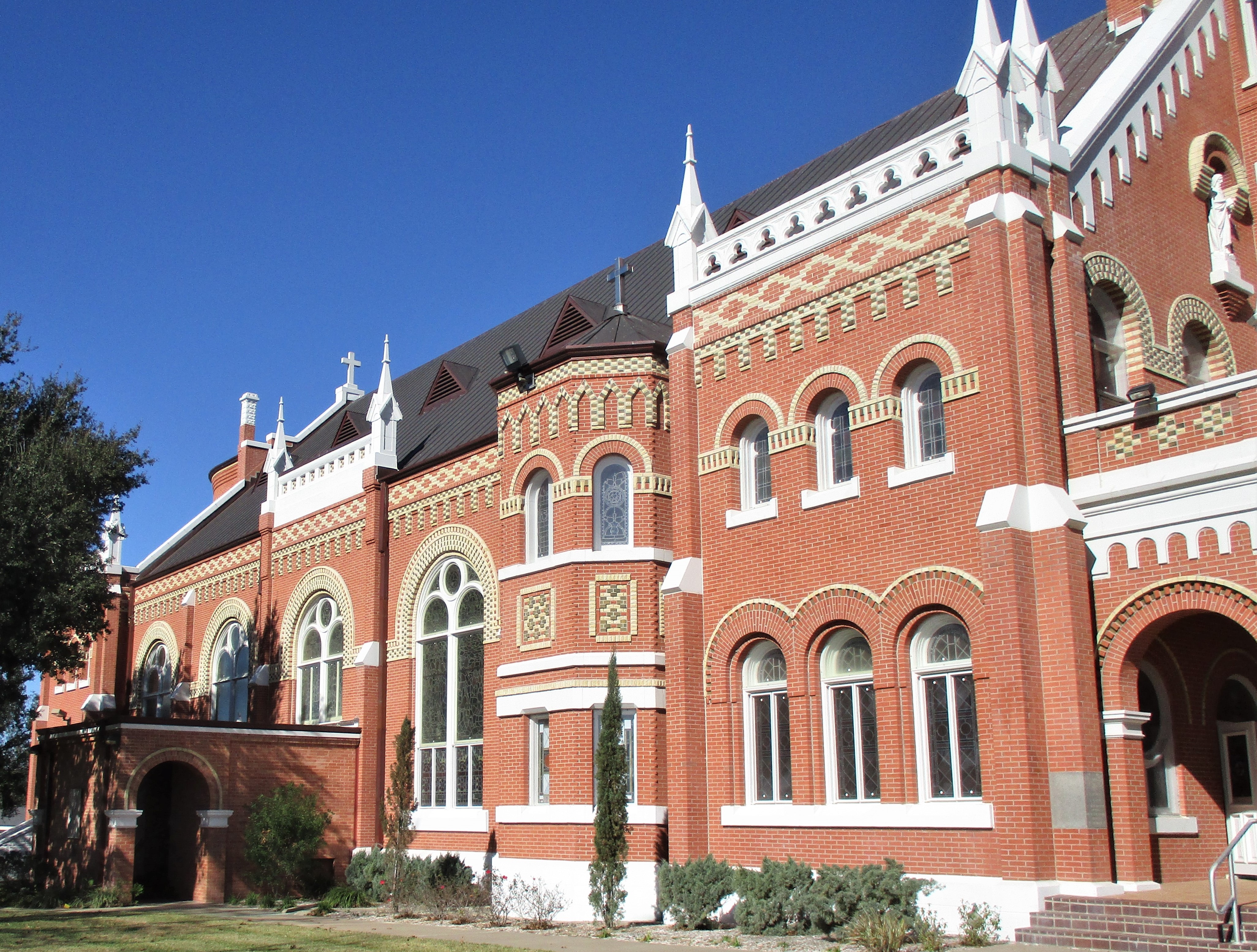
In this same area of town I passed a stunning-looking church.
St. Anthony Cathedral Basilica
The cornerstone was laid in 1903, and the church claims to be "one of the most resplendent houses of worship in the southwestern United States."  (Beaumont is so thoroughly in southeast Texas that being classified as a southwestern church seems odd.)

This whole area of town has lots of beautiful old buildings intermingled with very attractive new buildings.  Beaumont seems to be doing a good job of modernizing itself.  And then there's the nearby dog park decorated with a giant white water hydrant about 25' tall.  The only photos I could find were copyrighted, so I can't show you.

Beaumont appears to be proud of its local Lamar University, because I've seen a lot of ads for it.  It's a public college, currently with 15,500 students that I think are drawn from a large surrounding area.

Back on the road
I definitely planned today's route to skirt Houston, and this time I was successful.  

Instead I went through Baytown (pop. about 77,000), passing many chemical plants or refineries or both (I can't tell the difference).  At least one of them was the ExxonMobil plant, one of the world's largest ethylene plants.  Ethylene's used to force the ripening of fruit, and it's used in making polyethylene (usually used for packaging products).

I saw a billboard that read: 
     Biden = Mobs
     Trump = Jobs
plus 8 places (usually houses) with Trump signs and an additional 6 places with Trump flags.  I wouldn't have thought this populous and industry-oriented area of the state would be heavily in favor of the former president, but given all these signs, and the fact that the inauguration was more than 2 weeks ago, I guess I was wrong yet again.

I crossed the Houston Ship Channel on the Fred Hartman Bridge.  The ship channel allows Houston to be an international port by connecting ocean-going ships from the Port of Houston to the Gulf of Mexico.  Fred Hartman spent 24 years as editor and publisher of the Baytown newspaper (an interesting honor for a newspaperman).  This bridge is more than 2½ miles long and was a complete surprise to me, as I had no idea I'd be crossing it.  This was another one where I just took the center lane and did my best to keep my speed up and ignore the distance to the water and let all the other drivers drive their own cars without me worrying about them.
Fred Hartman Bridge
This aerial view of the bridge doesn't show what I saw at street level, but the pattern of those cables reminded me of a ship's sails and were really quite attractive.  They were a nice distraction from my usual fear of bridges.

This area south of Houston is highly populated.  As examples, on TX 146, I drove through Shoreacres, pop. 1,493; Seabrook, pop. 11,952; Pasadena, pop. 141,672; and Webster, pop. 9,083.  These numbers were from the 2010 census, and Pasadena alone has grown by an estimated 12,000 since then.  But if these 4 towns were combined into one city, it would rank #19 on the list of Texas's most populous cities.  In other words. there's a whole lot of people in the area not even counting the city of Houston.

Pasadena is the home of the Lyndon B Johnson Space Center, where all mission flight controls are located and all NASA astronauts have trained since the Apollo missions in the '60s.  I passed the entrance, and if you've seen The Martian, then you've seen the same view I saw.  (It looked just like itself.)
display of the shuttle carrier and a space shuttle
I didn't see it up close like this photo, but I could see it plainly because it's not that far from the entrance gate.  This is a permanent display of the shuttle carrier that carted space shuttles to and from the launch and landing sites for 35 years.

In Webster, I passed a sign directing me to the Challenger 7 Memorial Park, commemorating the 7 astronauts that died in the 1986 explosion.

I saw a sign advertising "Hey Fur Sail" with a phone number.  Has to be somebody with a sense of humor.

I passed more refineries and chemical plants, some of these for Chevron Phillips.

I heard on the radio that Christopher Plummer has died.  Tonight I'll watch Knives Out in his memory.  What a range of roles he's played over his career.

I also heard on the radio that the fastest growing religious designation in the US is "none."  Well, fervent church-goers shouldn't take this too much to heart: Americans have always been like a clock pendulum, swinging from one extreme to another.  This country has been through non-religious phases before and swung back to being church-goers; I fully expect we'll do the same this time.  I used to worry quite a bit about these extremes, but I think now that the point is that this country spends most of its time somewhere near the middle, a fact I find reassuring.

I came to Bay City (it's easy to get all these very similar names mixed up), pop. 17,509, which is the county seat.
Matagorda County Courthouse
in Bay City
The name "Matagorda" comes from the Spanish, meaning thick bush, referring to the canebrakes that were once thick along the coast (and probably prevented erosion and storm damage, in the same way the thick grasses that used to cover the US prairies held the soil in place and, when removed, resulted in the Dust Bowl).  The internet tells me that a canebrake is a giant grass, and appears to be a sort of bamboo.  What that word conjures in my mind is Tennessee Ernie Ford singing Sixteen Tons ("I was raised in a canebrake by an old mama lion . . .").  My mind is such a jumble of useless information by now I don't know how anybody'd know whether I had dementia or not.

I passed through the town of Blessing (pop. about 850), which got its name in 1903 when the railroad finally extended the rail line to the town.  They wanted to call it Thank God (I guess they really wanted that railroad stop), but the post office said that was unsuitable, so they changed it to Blessing.  (This story really strikes me as funny.  I hope you're as glad as I am that I look these things up.)

I passed through what I thought was the town of Deutschburg - I saw a large sign saying it was founded in 1911.  But if it was ever an actual town, I can't find it on the internet.  Instead, it seems to have been a close-knit German immigrant farming community that is continued today in its community center that still has events for the area residents.

I've seen several azaleas today that were in full bloom - very nice, though it seems a little early for them.  At the KOA I found a number of orange trees that were producing oranges, which surprised me.  Port Lavaca's only halfway down the Gulf coast of Texas, which I think of as too far north for oranges.

Tonight's KOA was a little unsettling to me in several ways.  For one, when I walked into the office, past several signs insisting people needed to wear masks, both the young women working there weren't wearing masks.  One of them put hers on to come stand right next to me, but I didn't find it reassuring because the other never did put one on.  For another, they had a smallish dog park, but they'd placed it out in the middle of a field, and the field was so sodden I wished I'd worn my rubber boots.  For still another, we were so close to a field of cows that I had frequent thoughts about the experiences of cowboys on cattle drives, listening to the lowing of the cattle during the night - they never seem to shut up.  And I worried that Dexter would suddenly realize those were cows over there and want to charge over to attack them, which fortunately he never did.  And for yet another, some of the campsites (not mine) were right on Carancahua Bay, which I'd never heard of but is an extension of Matagorda Bay, which I have.  So the entire campground got the constant wind and dampness that comes with being on the ocean but was a little disorienting since, to me, we weren't on the ocean.  Besides these, the owner complained to me that they weren't nearly as full as usual (explaining how I managed to get a reservation on a weekend, even in February) which he assumed meant the weather was about to change for the worse (not reassuring).  And as a final oddity, they had signs plastered all over the campground advertising Hunt Pizza, but when I asked at the office if they delivered, the young woman said a little grumpily that they would if they had enough staff available.  Which I took to mean no.  So with all that, I was glad I'd only planned to stay one night here.


Friday, February 26, 2021

Texas - Days 91 - 93 - in the campground

Village Creek State Park, Lumberton
Tuesday, 2 through Thursday, 4 February 2021

For some reason, I wasn't expecting much out of this state park, but it worked out very well for us.  We had 2 different spaces, both of which had a distinct slant to them.  But other than that, we were comfortable.  I could get an internet signal on my hotspot, there was a phone signal, and I could pick up the Beaumont CBS station for the morning weather report.

This is a small campground - only 25 spaces, one of which is taken by a camp host.  More than half the campers seemed to have dogs, but our location let me see if any were out walking before we left our RV, which helped avoid problems.  

Trails
There are a number of trails in this campground, and though I don't usually want to risk taking the dogs down trails - for fear of running into wildlife or other dogs and lose control of one or both of them - I didn't have that worry this time because of the layout.  What I did have to worry about at first was fear, induced by this sign:

The fear wasn't so much for me but for the dogs - I kept expecting any minute that Dexter would eat some ghastly plant or Gracie would nose out some scary snake.  Fortunately, none of that ever happened.

One of the trails was only half a mile long, though it wasn't a loop so we ended up walking about 3/4 mile altogether.  The trail was a fitness trail, laid out by a Girl Scout who was working toward her Gold Award, which is a rank I hadn't heard of.  It sounds like it's something like the Eagle Scout award for Boy Scouts.  When I looked up this Gold Award, I found a number of stories of projects Girl Scouts had put together, and this one in particular surprised and touched me.   https://www.girlscouts.org/20-national-gold-award-girl-scouts 

The Girl Scout who laid out this trail included exercise stops along the way - but I was impressed to see that she hadn't used fancy equipment that would become nonfunctional without maintenance.  Instead, she'd used pieces of wood, like 2x4s, to build stair steps or balance poles - items that blended in very well with the heavily wooded area the trail ran through and yet were perfectly functional.  She also created signs showing how to use these items for 3 different levels of difficulty, and the signs included photos showing actual girls performing each of the tasks.  It was very well done. 

We found another trail that was intended for little kids and is only a tenth of a mile long.  The signs along the path originally explained how the Big Thicket came to be, how the variety of plants that would normally be found in other parts of the US came to be here.  Sadly, the signs had badly weathered so they were scarcely legible.

This first one is called How Are You My Neighbor?

Below this was an outline of the Lower 48, showing various plants and animals that ordinarily belong in other climates but are found here.  I can't make out any of the animals except White-tailed deer, though I can't tell where they're usually found.

Arid Sandylands from the western US
& plains from the central US

Swamps from the eastern Gulf Coast
and Longleaf pine forest from southeastern US

Hardwood forest from the eastern US


This next sign was titled Life In the Sand:


Explaining that this park gets far more rain than some of these plants and animals
usually want, but they're able to thrive anyway because of the sandy soil here.

Bear Grass Yucca & Eastern Prickly Pear Cactus


Reindeer moss & Six-lined Racerunners


The next sign was titled Swamp Things, but the only creature that was at all legible was the River Otter.  I'm sorry that I didn't see one of them while I was here, though I saw them often enough in Alaska and it's just as well that Dexter didn't see one.  Still they're neat animals.

Then there was this sign about the different kinds of pine trees here:
Longleaf pine - best pine for building and are more
resistant to fire than other pines, but they need full sun and,
because they're much slower growing than other pines,
can be blocked out of an area for lack of sun.


Loblolly pine - prefer a more moist soil than other pines
and are very fast growing, but are more vulnerable to
fire than other pines

Shortleaf pine - can grow in drier, sandier soil
and in colder areas than other pines and
are found as far north as New York state.


On one of our walks around the park, we met a ranger and I asked him about a large burned area nearby.  He said it had been a controlled burn and that the park was about to plant a bunch of Longleaf pines there.  He said the area had been full of Loblolly pines, which grow much faster than the other types.  Longleaf pines need full sun to grow, but the faster growing Loblollies blocked out the sun and they ended up taking over the area.  The park was working to correct that little mistake by Nature to restore the ecosystem as it had been.

Another trail we walked . . .
. . . in the Big Thicket.


Wildlife
As it happened, the only wildlife we saw were some birds and a few squirrels.  But I know there were deer somewhere in the vicinity because the park had one of those leaping deer signs that warn drivers to slow down.  And I saw plenty of signs of moles in the area, just not the critters themselves.

I did learn a new bird species while we were here: the Hermit Thrush.

Hermit Thrush
The one I saw looked just like its picture, including the eye ring, the reddish tail, and the way it raises and lowers its tail from time to time.  It sat on a railing right by my window for several minutes, giving me plenty of time to get a good look.

The best part is that I think I've finally figured out that it's this bird that's been making that wonderfully sweet song I've heard occasionally during this trip.  I remember hearing it for the first time up in the northeast somewhere.  A song so pure and sweet it makes my heart swell almost to breaking.  And the bird book says the Hermit Thrush has a song that's "a serene series of clear, flutelike notes."  Serene.  Clear.  I'm betting it's a Hermit Thrush I've fallen in love with.  

Texas and the southern US is part of its winter range.  They seem to live year-round only in parts of Arizona and along the far western coastline.

Miscellaneous
While we were staying in this campground, I heard that Hal Holbrook died.  In his memory I watched not only All the President's Men but also the episode in Season 4 of NCIS titled Escaped, which has Hal Holbrook guest starring, and McGee helps solve the crime by what he learned watching Antiques Roadshow.

We went into town one day - well, actually, the park is already in town, so I mean I drove out the park entrance, down the street, and turned the corner.  I wanted some groceries and I thought I'd try to find some place new for the dogs to walk.  That last turned out to be very difficult: schools were in session, churches had tiny parking lots or forbidding signs, shopping centers were too small and too busy.  I guess the folks in town use the state park as a park, since I never found a city park.  I was finally so frustrated, I did something I'd thought of for a long time but hadn't done in years, which is to stop at a Southern Maid doughnut shop for a cinnamon roll.  Considering its size, Lumberton sure doesn't seem to have much going for it.  But the cinnamon roll was good.

And the campground was comfortable.  We all enjoyed staying here.


Monday, February 22, 2021

Texas - Day 90 - across southeast Texas

Village Creek State Park, Lumberton
Monday, 1 February 2021

today's route
During this visit in Bastrop State Park, I noticed something I'd missed on my last visit, which is that many trees seemed charred at the roots - I assume from that devastating fire in 2011 - "the most destructive wildfire in Texas history," per Wikipedia.  And this time I noticed the large number of young pine trees that had been planted to help the area recover.  If you were seeing this area for the first time these days, you couldn't even dream of how thickly forested it used to be.  I'm lucky to have that memory, but I'd forgotten it until this visit showed me more clearly just how much damage had been done.  Fire is like flood - a natural force that can't be stopped and that can radically alter the world.

Before I left the campground, I saw a news report of someone who'd been driving so fast he'd actually plowed under an 18-wheeler.  He was killed, of course.  The semi driver was okay, though undoubtedly shaken.  The picture of the wreckage was something every teenage driver (and quite a few adult Texas drivers) should be made to look at for its incredible damage.

On the road
I had a long drive planned today, since I was essentially crossing half the state to get from central Texas to far east Texas.  I planned a route that kept me off the interstate for most of the way.  But I seemed to have little alternative to going through Houston - it's like when you fly Delta Airlines you almost always get routed through Atlanta whether you want to or not - and going through Houston almost requires a spell on the interstate.  Still I found a couple of county courthouses on the way.

Near Giddings, I passed a complex of greenhouses covering an area the size of a subdivision, with more in process of being built.  I didn't see a sign so have no idea what company is using them.

In Giddings I passed the Lee County Peanut Company.  I hadn't known that we grew peanuts in Texas, but apparently so.  Their webpage is on Facebook, which I can't access, but I did see that they also sell pecans, which Texas produces plenty of.  Maybe sometime when the pandemic is over, a visit to the Peanut Co. would be a good idea.

During a stop I noticed that the RV wash I got in Leander had been too harsh on my paint and decals.


It's a real shame because there's absolutely nothing I can do to repair the damage.  I wanted it clean, but I hadn't intended to pay this high a price for that.

Carmine
Established in 1883, Carmine (pop. 250) bills itself as the Gateway to the Antiques Fair, referring to the extravaganza held in even smaller nearby Round Top (pop. 90) three times a year.  I passed a building without any sign other than "Martin bird houses" which suddenly reminded me of Burt's Birdhouses.  Every time I passed here, I saw an incredible display of birdhouses handmade by this man.  Of course I often thought of stopping to buy one but never seemed to have the time.  And today I saw not one birdhouse.  In fact, no sign of life, let alone commerce.  

It felt like something had been taken from me, because it's always been such a happy display.  In fact, when you think about it, a birdhouse is a very happy thing on its own.  And today they were gone.  I don't know if it's because of the pandemic or if it's because it's winter or if maybe something's happened to Burt (though I certainly hope not).  I can't exactly use a birdhouse right now, but if anyone's passing that way and sees them out again, buy one for me.  There's always the future to look forward to.

I also noticed that Carmine seemed to have more businesses and the houses were more spruced-up than I remembered.  Maybe that's just my faulty memory, but I was glad to see the town looking more prosperous.

Washington County
Washington County, named for George Washington, bills itself as the Birthplace of Texas - for once, a claim with some backing to it.  In 1836, while the Alamo was under siege, delegates from each community in Texas met at the town of Washington-on-the-Brazos, where they declared independence from Mexico, wrote a constitution, and organized a government.  Pretty heady stuff.  Today, about 250 people live in the area.

I came to Brenham, the county seat, which the highway department didn't bother to put up a sign for but I learned has a population of about 17,000.  It looked like half those folks had gone to the H-E-B - the parking lot was completely full at 10:30 AM.  On a Monday.  I have no idea why but decided to postpone my own need for groceries to avoid a crowded store.

Washington County Courthouse
in Brenham
This was built in 1939 in the Art Deco style.  That's hard for someone like me to tell from this photo so I enlarged the entrance.

You can see some of the details a bit better here.
A short distance from town I came to Chappell Hill, which must be situated away from the highway because I've never seen anything along the roadway that would suggest 600 people live there.  This town was part of Stephen F. Austin's original colony.  This trip, I noticed for the first time that I was passing the Chappell Hill Sausage Company, apparently a going concern because I saw a couple dozen employee vehicles parked by the building.  They say they've got a restaurant and gift shop, so sometime I'll have to stop off and sample the local product.

Houston area
The town of Prairie View didn't have a sign but has an estimated 6,428 residents as of 2018 (how can they estimate so exactly?).  What I've always known the town for is Prairie View A&M University, a historically black college.  I hadn't realized it's also the 2nd oldest public university in Texas, founded in 1876, and one of 2 land-grant colleges in the state - Texas A&M University being the other.

This is information I found online, and I was confused because I'd always heard the University of Texas was a land-grant college too.  Turns out that's right - but UT got its grant of land from a different source.  The A&M schools got their land grants from Congress in 1862, but the state legislature hemmed and hawed for nearly 20 years before actually doing something about it (shows that nothing's changed in the Texas Legislature).  While it was pulling itself together to deal with the A&M land grants from Congress, the state Leg did its own land granting to establish UT.  Famously, the land that got granted was wasteland out in west Texas.  In 1923, the Santa Rita No. 1 well came in a gusher, and Texas's universities have been spending money ever since.

Anyway, Prairie View A&M was established when Texas A&M was, as a sort of early separate-but-equal situation.  Prairie View finally got its share of the oil wealth beginning in 1983 when the Leg gave it beneficiary status to the land-grant proceeds.  There's a moderately interesting discussion of the origins of the state schools at this website.   https://texasalmanac.com/beginnings-universities

I tried my hardest to avoid driving in or through Houston, to no avail.  The highway signs didn't say what Google said they'd say.  For instance, Google said I should turn onto I-610 E(ast).  Except there was no I-610 E.  There was an I-610 W, which is where I'd come from, and an I-610 S(outh).  Of course I turned S, which was wrong.  I figured that out when it became clear the road wasn't going to swing east away from town but instead was getting closer and closer to the main part of town.  Instead of finding Exit 24, as Google had promised, I finally gave up when I got to Exit 6.  Then I had a heck of a time trying to find someplace - anyplace - to stop on those city streets long enough to pull out a map and reorient myself.  Thank heavens for AAA maps, because I was able to find exactly where I was right away (and I'll bet it was faster than anybody could have done online, too) and figure out where I should be going.  When I got back to where I'd started this mess, I found an I-610 N(orth) that I hadn't seen before, and that finally got me back where I needed to go.  I never did find I-610 E.

But then, of course, the next turn Google said to take didn't do what it claimed either, and I went the wrong way yet again.  (Grrr.)  But I did finally get on US 90 heading east.

Dayton, TX, and Cleveland, TX, are about 30 miles apart.  I assumed their names came from Ohio, and I was wrong.  The name of Dayton seems to have just come up as a railroad stop, and Cleveland was named for the man who donated the land for a railroad stop (everything's about railroads in this country's history).

Liberty
This town, established in 1831, claims its location halfway between Houston and Beaumont as a selling point, which I guess it is.  The town had no sign, but its population was estimated in 2018 as 9,349.  And it's the county seat.

Liberty County Courthouse
in Liberty
This courthouse, built in 1931, is the 7th such building for this county.  Surprisingly, only the 4th burned; all the others seem to have been merely replaced.  You might be able to tell from all the cars I tried to crop out that I had trouble getting this photo.  The building is awkwardly placed and doesn't have a square of its own but instead shares a plot of land with other buildings.  There's little parking available and the streets are much narrower than I'd have expected for a county courthouse.  I guess that's the way they want it.

The nearby town of Ames has a population of 1,003, according to the highway sign coming into the town from the west.  But it has a population of 1,079, according to the highway sign coming into the town from the east.  The first is the result of the 2010 census.  I don't know where the 2nd came from because the 2018 estimate is 1,154.  Maybe it's a Twilight Zone kind of thing.

A little farther down the road
Soon after Ames I came to Nome.  Ames being in Iowa and Nome being in Alaska, I felt a little disoriented, especially coming so soon after Dayton and Cleveland.  In the case of Nome, I wasn't wrong: in the early 1900s, the town was inundated with oil field workers, much as Nome, AK, was being taken over by would-be gold miners, and the Texas town changed its name to match the well-known Alaska one.  (That's apparently a true story.)

What I saw at Nome, pop. 588, were large flat fields, which I supposed were for raising the cows and turf I also saw.  But I now know that Nome, and the nearby town of China (seriously), were and still are a center for the Texas rice farming industry.  So there's 3 reasons for the large flat fields I saw.  None of that accounts for the half a herd of cows I saw that were all running across a field.  Actual running.  Weird sight.

Another short distance and I came to the town of Sour Lake, named for the sulfur springs nearby.  It has 1,813 residents and, when I was there, a "Missing: Red German Shepherd."  I'd never heard of a red German Shepherd before, but they're apparently like regular German Shepherds with a distinctly red tint to the usual tan and black coloring.  At any rate, I always worry about missing dogs and wished I could be of help.

And finally I came to the town of Lumberton, pop. 11,943, where tonight's state park is.  I guessed that the town's name came from the timber harvesting industry, which was extremely active in all but eliminating the Big Thicket that used to cover this part of the state.  And my guess was right, insofar as the original post office serviced the local sawmills and lumber camps.

I can't quite tell why Lumberton is as large as it is, let alone why it continues to grow rapidly.  I didn't see any particular industry in town, but it's a fairly short drive to Beaumont and seems to be developing as a sort of suburb.  Not having been to Beaumont, I can't say whether I'd make that decision to live here instead of there, but I wasn't wildly impressed with Lumberton.  It looked like a dusty hodgepodge of chain and local stores with schools and ordinary houses all crammed together.  It definitely looked much smaller than the 12,000 people it claims as residents.

On the other hand, I met a very nice woman who gave me perfect directions to get to the state park, once Google's directions had failed me (for the 3rd time today).  Really, I've never had such accurate directions to anywhere by anyone.

And so to Village Creek State Park, where I have a reservation for the next 4 nights.


an oddball side note

Monday, 22 February 2021

For the entire last week, I've been feeling a mite poorly, as we used to say when Texas was more rural.  I'm pretty sure I had the coronavirus but have been lucky not to have any respiratory symptoms, as far as I can tell.

Today is the 10th day since I first felt the symptoms, and I'm definitely feeling better - still not 100%, but definitely better.

I've been lucky in many ways and will write about this in more detail when I come to that post in chronological order.  But this is why I've been so silent for so long.  Thanks to luck and a generally healthy constitution, I expect to be completely on the other side of this in the next day or so and will soon resume my blog postings.

Hope everybody's able to stay well and warm.

Thursday, February 4, 2021

Texas - Day 89 - Painted Churches

Bastrop State Park, Bastrop
Sunday, 31 January 2021

today's route

Puppy pick-up
The boarding place was our first stop, and it was really nice to see the puppies again.  Invigorating, but nice.  Since I knew I'd be cleaning their bedding while they were gone, I'd asked to have them washed, too.  They were definitely clean, but this place isn't a grooming salon, so Gracie hadn't been brushed, meaning she still had a lot of unneeded hair on her.  While the dogs were gone, Lily and I enjoyed a nearly hair-free floor.  In fact, I got used to it, so this morning I got a shock when, within a couple of minutes of picking up the dogs, we had hair on the floor again.  Oh well.

On the road
I've heard about the painted churches in this part of the state but never seen any of them.  It was hard to find information online that would tell me whether, given the pandemic, they were open for visitors.  Actually, I wasn't even sure what they'd look like if I did find them open.  But since I was in the neighborhood, dropping by seemed like a worthwhile goal.  There are others - for instance, at Fredericksburg in the Hill Country - but I found 6 here in the east within a day's drive of each other.

Less than 2 miles from the boarding place is Airport Blvd. in Austin, which becomes US 183 just south of town.  We stayed on US 183 for more than an hour, turning off when we got to Gonzales.  My first goal was Shiner.

Shiner
The sign said "Welcome to Shiner - Cleanest Little City in Texas."  And they weren't kidding.  The cleanliness was noticeable - zero litter, no grime on the buildings - even those that were empty - and it made every other town look slovenly.  Shiner's population was 2,069 10 years ago, and it's the home of Saints Cyril and Methodius Catholic Church.

Sts. Cyril & Methodius Church
in Shiner


The church was built in 1921 and is absolutely gorgeous inside. 

I got there just as Sunday mass was ending, and waited for the congregants to file out of the church before going in.  Once inside, though, I was stunned by the church's decorations, and stood in the back trying to take them in.  But because there were still quite a few people in there, I didn't want to take photos that I thought might seem intrusive, as if this were a tourist spot instead of a house of worship.  I'll have to go back sometime for photos, because the church was breathtaking.

Back on the road
Just outside the town of Hallettsville, I happened on some signs saying that area where I'd pulled over was the "Holy Mother Mary Apparition Site."  There's not a lot there, as this article suggests,   https://www.victoriaadvocate.com/shrine-honors-apparition-of-virgin-mary.  What I saw was a small valley with several little shrines and a few religious symbols.  Still, it wasn't something I expected to see.

Hallettsville
Hallettsville, "City of Hospitality," with 2,550 residents, is the "Home of the Brahmas" (I'm guessing high school team), as well as the Lavaca County Courthouse.
Lavaca County Courthouse
in Hallettsville
Built in 1897, it looks Gothic to me, but I'm informed online that it's in the Richardsonian Romanesque style (whatever that is).  You might be able to see the word "Peace" on the front of the building.  The other 3 sides continued with "Hope," "Love," and "Joy."  I imagine they were put up as Christmas decorations, but in these continuing days of coronavirus, they're sentiments that haven't grown old.

Sublime
From Hallettsville, I drove another half hour east to the town of Sublime.  Since it wasn't that far out of the way, I thought it made sense to visit there on the day I'm visiting painted churches.  

The town is unincorporated and I have no idea how many people live there, other than not very many.  It seems to have about 6 streets, all of which are about 1 lane wide and 2 blocks long, and most of which aren't paved.  (Google lies when it says they have names; instead, the signs say LCR [Lavaca County Road] 142A or B or C.)  

I guess it's an agricultural town, but there's obviously not much disposable income there.  I thought it was interesting that I myself saw both a Baptist and a Lutheran church, both of them decent-sized buildings.  I wouldn't have thought the area could support 2 congregations that could support 2 churches, but I guess they take their town's name seriously in a religious sense, despite the standard of living apparently being not at all sublime.  

In this small town I saw a small Trump sign and a large Biden/Harris sign - this one saying "Make America Think Again."  Speaking of which, I was interested to note that over the course of my 8 hours of driving today, I saw 7 Trump signs and 16 Trump flags.  It seemed like a lot, considering what's been happening, but I think it may be a lot fewer than there were.  I covered 230 miles of rural east Texas - the sort of country where every town has a 4-H Club - and I would have thought it was prime Trump country, so maybe 23 signs of support aren't all that many.  What I also saw were lots of homes flying both US and Texas flags.  Between Hallettsville and Sublime I saw a Confederate flag next door to a Texas flag across the road from a UT flag.  So take your pick.

Moravia
Back to Hallettsville and turning north, I came to the town of Moravia, which has a highway sign but may be a ghost town, according to this article.   http://texasescapes.com/Moravia-Tx  What Moravia still has, though, is a painted church.

Ascension of Our Lord Catholic Church
in Moravia
Actually, I'm pretty much taking it on faith that it's a painted church because it was locked.  But I looked through the door at the end (on the right, above) and found I was looking right down the sanctuary.  The only light was coming from the windows so I couldn't see much, but it looked like there was definitely some decoration that I'm sorry I didn't get to see.

Right next to the church is a very full cemetery, with names like Hanacek, Broz, Halata and Konvicka, showing the Czech origins of the original settlers.

Praha
Less than a dozen miles from there I came to the town of Praha, which is Czech for Prague.  The town is either unincorporated but functioning, or it's a ghost town, depending on who you believe.  What I know is that there were a number of houses in the neighborhood of the church, which makes it not very ghost-y to me.

And a note about my labels: I'm giving these churches the names on the signs in front of each of them.  As you can see on this historical marker (below), they all have other names assigned on various websites and articles.  I stuck with what they say they want to be called, according to their own signs.

St. Mary's Catholic Church
in Praha


the front doors


close-up of base (above left)

ceiling decoration

detail of side panels


Is this for St. Joseph?
I'm not a Catholic so don't
know the symbolism - sorry.

detail behind the altar


organ balcony

confessional


I didn't want to use a flash on these photos, but when I tried to lighten them on the computer, the colors tended to wash out.  What you see is my best compromise between too dark and too colorless.

High Hill
Eleven miles away is St. Mary's Roman Catholic Church in High Hill which, again, is either an unincorporated town or a ghost town.  And, again, I saw quite a few houses around the church, so I'm going with unincorporated rather than ghost.  This church is considered The Queen of the Painted Churches.

St. Mary's Roman Catholic Church
in High Hill
the sanctuary


closer view of the ceiling
closer view of the sanctuary


St. Joseph?

organ balcony


some of the stained glass windows


much fancier cornerstone than usual

3rd side of the cornerstone


Back on the road
From High Hill I turned down High Hill Road, which became a farm-to-market road, which became Piano Bridge Road.  Along that road I passed a sign saying "WEAK Bridge - No Turnaround," which seemed ominous.  It's just that they didn't define "weak" so I had no idea whether that included me or not.  But since I've crossed other bridges that had warning signs on them, and since I've turned around in places where I had no business trying to turn around, and since I didn't have a clue what an alternate route would be, I decided to keep going.  

The bridge turned out to be a very old iron bridge, made in "Cleveland, O." (it said on the bridge), and had a wooden ramp up to the bridge on one side and down from the bridge on the other.  It also had a sign saying "Gross Weight 16,000 Lbs." so I decided not to worry.  And it turned out the only thing I had to worry about was how narrow it was - we just barely fit on it.

Another quarter mile or so farther along was what's left of the town of Dubina.

Dubina
Wikipedia says it's an unincorporated town of 44 people, but from what I saw, it's a ghost town.  I didn't see any houses anywhere near the church.

Sts. Cyril & Methodius Catholic Church
in Dubina
another Czech
inscription at the base

the sanctuary

closer view of the detail
This church was open, but a metal grill kept all visitors just outside the sanctuary.  I got these 2 photos by sticking my camera through the grill, and that kept me from getting more detailed views of the decorations.

In the foyer where I was, the church offered a brochure with a very detailed history of the area.  It said the church was built in 1911 (after the previous one was destroyed in a hurricane) and the interior painting was finished in 1913.  But that's not what you see above.  Instead, in 1952, some brilliant interior decorator decided to paint over all the original decorations.  Local artisans repainted the interior in 1983, and that's what you see now.

Ammannsville
A 6-minute drive farther brought me to St. John the Baptist Catholic Church in Ammannsville, still another unincorporated/ghost town with houses around the area.

St. John the Baptist Catholic Church
in Ammannsville


I was sorry that this church wasn't open; a sign on the door said visitors were welcome during regular business hours, which didn't include the Sunday afternoon when I was there.  This church is known as the Pink Church, and though  they say it's because the interior is pink, I honestly don't know why.  At this link   https://austinot.com/painted-churches-of-texas there's a photo of the interior, and maybe in real life it's pink but in this photo I'm not seeing it.

Back on the road
And from Ammannsville, it was another 45 minutes to Bastrop State Park.  We passed a few oil wells, lots of cows, and farms everywhere.  I saw a mama cow licking her calf, who stood there much more patiently than do most little kids getting groomed by their mamas - very sweet.

By the time we got to the campground, I was pooped.  I'd left the campground this morning at 7:00, and we didn't get into Bastrop until 3:30.  Long day.  But the dogs had slept like logs for the whole driving trip (except for bouncing like mad every time we stopped), so they were ready for more walks.  The campground had plenty of big dogs, but I was lucky in the numbers not being as high as they could be because the campground wasn't completely filled, though it'd looked like it would be when I made my reservation.