Tuesday, January 31, 2023

Florida - Day 15 - the Everglades, via Key Largo

Long Pine Key Campground, Everglades National Park
Wednesday, 31 January 2023

You have to piece these two map sections together, though there's still some places missing from these two views.


The Tamiami Trail, aka US-41, which is what we spent much of the morning driving along, seems longer than the mileage says.  Probably because there's not a lot of variety in the scenery.

There were marshes and some kind of water body (a canal or creek or something) alongside the road for miles - 55.7 miles, to be exact.  Utility wires were strung beside the road all along the way, and I saw kingfishers and herons and egrets and grackles perched on those wires and on trees growing by the road.  Cormorants and/or anhingas.  And probably lots of others that I couldn't identify.

As you can see on the map, we passed through the Big Cypress National Preserve.  This one and the Big Thicket in Texas became the country's first national preserves when they were both established in 1974 (hard to believe they were created that recently).  Actually, Big Cypress was supposed to be included when the Everglades were established (1947) but some of it was still privately owned and - of course - oil had been found in one part of it.  There's an interesting discussion of this as well as other developmental pressures here on the Wikipedia page.   https://en.wikipedia.org/Big-Cypress-National-Preserve

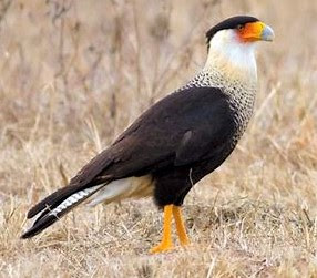
I saw more panther crossing signs, one with a blinking yellow light, which makes me think that's a popular panther area.  Wish I'd seen one.

I also saw signs that said I was "entering a wildlife sensor area" and later that I was leaving it.  Can't find anything specific online but assume this is a tracking effort to locate panthers and other species.

I saw lots of other miscellaneous "animal crossing area" signs.

Another sign told me, "Welcome to Miccosukee Tribe."  I'd never heard of them and looked them up and found this fascinating history.   https://www.miccosukee.com/history  Their strategy of using Fidel Castro to gain federal recognition of their tribal status is incredible.

We stopped for about an hour at the Shark Valley Visitor Center, part of the Everglades.  I was disappointed to learn there's no road through this section, just hiking trails.  It was already getting hot and I didn't trust Dext around strange wildlife (like alligators), so we just walked around the parking area.  And I found some informative exhibits inside.  There's a glare on some of these, but they're interesting if you can read them.

The Everglades is huge.
This shows the water flow from north to south.

This shows the freshwater/saltwater areas.

A different way of explaining this.

An example of the effects of salinity change.


much of this is enlarged below


Some of the vegetation and who depends on it:


It wasn't labeled but I'm guessing this is sawgrass around a willow hammock.


alligator/turtle coexistence
more alligator/turtle coexistence


A ranger at Shark Valley explained to me that one way they're increasing the flow of the Kissimmee River into the Everglades is to knock down the dam that was formed by the Tamiami Trail and replace some of it with bridges.  He said they built 3 new bridges in the last 5 years along that road.

When I got back on the road, I saw some of those bridges - they're the same level as the rest of the road (low) so they're not really noticeable, but they're long, allowing a lot of water to pass through.

I heard on the radio that this is National Plan A Vacation Day.

At Homestead, I picked up US-1 - the road that runs (basically) from New England down to Key West.  I think it's the only road that runs down to the keys, and I wanted to go as far as Key Largo.  I chose it mainly to honor the old Bogart/Bacall movie, but also because it's the closest.

But first I did a little shopping, got some gas ($3.43/gallon), passed a lot of roadside produce stands, and saw a field of corn that had grown enough that I could identify it easily.

I passed a Cemex plant.  A sign told me Homestead would host a Stone Crab and Seafood Festival in March.

I crossed from the mainland over to the islands, feeling like I was driving on a causeway, because I had a long body of green water on both sides of the road.  But I can't find anything online about it - maybe because all the bridges taking US-1 down to the lower part of the Keys are more remarkable.

I passed the Florida Keys National Marine Sanctuary and then was told that Key Largo is the Diving Capital of the World.  Apparently one reason for this is that it has the world's largest artificial reef, which sounded weird to me until I learned that the reef formed around the U.S.S. Spiegel Grove (510' long), which was intentionally sunk off Key Largo in 2002.  There's also the John Pennekamp Coral Reef Park, which I passed.  And as a bonus, there's the African Queen - the African Queen - which has been refurbished and is available for daily cruises.

I passed a number of RV parks, all very crowded.

Back on the mainland, a sign told me I was on Harriet Tubman Highway, which I found very surprising given that Florida wasn't an area she worked in, as far as I recall.  But I found that it's an effort to rename the Old Dixie Highway - which I traveled on myself near Tomoka State Park.  Here's a fascinating account of how that decision happened in the town of Coral Gables.   https://www.local10.com/coral-gables-changing-us-1-name-to-harriet-tubman-hwy

Eventually (it seemed like it took a long time), I entered Everglades National Park.

Instead of going straight to the campground, I drove all the way to the end of the road at Flamingo Visitor Center, at the far southern base of the park.

Signs along the road told me I was going through Rock Reef Pass, elev. 3', and Dwarf Cypress Forest, elev. 4'.  For perspective, the official highest point in Florida is Britton Hill - 345' high - up by the Panhandle.  The whole state is at or near sea level.

What I saw along this road was miles and miles of grass, interspersed with clumps of bushes and trees - just as was explained in those signs at Shark Valley Visitor Center.  It was disorienting because, for some reason, I'd always pictured the Everglades as being a forest.  This was a forest only if you're about the size of a rabbit.  For perspective, I saw some Great Egrets standing in the middle of some of this grass - they're about 3' tall, and I could see their heads above the grass.

At the visitor center, Dext and I walked around the very shady parking area, dodging a flock of White Ibis feeding in the grass.  And actually, Flamingo Visitor Center itself was closed because of damage from Ian.  All they had was a small portable building, so they didn't have many exhibits.

We'd passed a large tract of dead trees near the visitor center, and a ranger told me it was due to heavy saltwater incursion from one of the hurricanes.

Then all the way back through the park to the turn for tonight's campground.  I felt lucky to get the reservations for the next 3 nights - even though there're no hookups here.  I ran the generator (so we could have AC) until 8:00 (the cut-off time), and then opened up all the windows and skylights to try to get us enough air to cope with the 70° that was forecast as tonight's low temp.


Monday, January 30, 2023

Florida - Day 14 - through Ft. Myers and Naples

Collier-Seminole State Park, Naples
Monday, 30 January 2023

today's route
I passed a sign for the Ortona Cane Grinding Festival the first Saturday in February.  Ortona is unincorporated and apparently quite small, but the festival sounds like fun, including bluegrass music and - what else? - cane grinding.

I passed a turn for the Ortona Indian Mound Park, and I'm not sure much is left of the original mounds.  Apparently there's an archaeological site there, but the mounds, which are still visible, have been mostly destroyed.  One had the entire center hollowed out, presumably by those searching for artifacts.  Two were destroyed when they were mined for use as fill dirt.  And much of the land is still privately owned.  So much for heritage.

An unusual sight: I saw a cowhand with 2 dogs pursuing a large cow running along inside a fence near the road.  They were running toward a large livestock transport truck.

At LaBelle, we crossed the Caloosahatchee River (amazing names, these Florida rivers) and saw the Hendry County Courthouse with a tall clock tower, set to the right time.
Hendry County Courthouse
A little way down the road we passed several RV parks, including one named Riverbend Motorcoach Resort.  Definitely sounds high class.  And expensive.

We passed large nurseries.  Cows.  Marshes and ponds.  Mixed woodlands.

And then to Fort Myers, est. 1886.  Hurricane Ian tore through this area just 3 or 4 months ago, and I saw some pictures of the destruction it caused.  I expected to see the town still pretty torn up because of it.  Instead, I saw that many business signs were gone and some roofs had been damaged, and likely some of the vacant lots had once had buildings on them.  And that was it.  I went through the main part of town and drove around a bit, but you'd never know from where I was that there'd been such a bad storm.  I was impressed with the resilience of the residents, to have cleaned up this thoroughly this quickly.  

I remember Momma and me driving along the coast road a year or two after Katrina and still saw extensive damage in Gulfport (MS) and other towns along there.  And maybe if I'd gone over to the coast here at Ft. Myers I'd've seen something similar.  But here in town, they've cleaned up well.

I still remember hearing on the radio the mayor of Ft. Myers bemoaning the fate of his "charming city" - and quickly saying that it was still charming, just messed up.  Well, I have to agree that this is a charming town, one where I'd like to spend more time.

I saw a sign directing me to the Edison and Ford Estates - as in Thomas Edison and Henry Ford, who built houses next door to each other.  There're tours now at those places and, while I'm sure it's very interesting and I'd enjoy it, the tour costs $25, which I think is excessive.

I'd heard somewhere that Cape Coral, near Ft. Myers, has a 6.8% growth rate - one of the highest around.  And a 2017 article I found online seems to confirm that, along with a scathing commentary on the contradiction that Florida is: seriously prone to weather damage while people keep moving here at a rapid rate, impervious to the real possibility of losing their home and their investment almost any time.   https://www.politico.com/magazine/fastest-growing-city-america-florida-cape-coral  This article also makes some interesting points about the political makeup of Florida in relation to environmental choices.

I'd heard that Cape Coral too was seriously damaged by Hurricane Ian, and found several articles agreeing that it was.  Somehow I doubt that will stop people from continuing to move there, though.

I'd picked up US-41 in Ft. Myers and stayed on it all the way south.  This road is also called the Tamiami Trail, and it runs across the north side of the Everglades to Miami.  In fact, the name comes from it having been built as the Tampa to Miami Road.  

There were many towns along the road and, at Estero, we made a turn for a dog park.  This turned out to be a very large fenced area - 2 areas, actually, because one was for small dogs.  But when we got there, all the action was in the large dog area, which worked out fine for us.  Dext got to meet quite a few new dogs and I was proud of how well he's handling this dog-meeting situation these days.  Being rushed by a number of dogs at once used to make him really defensive and upset, but he's not like that now that he doesn't have to worry about Gracie any more.

The dogs' people were there talking about the ugly behavior of the adult child of one of them, with the focus on provisions in her will.  I'm glad to be reminded occasionally that my life is essentially without drama; it helps me feel calm.

The road took me through the towns of Naples Park and Naples, neither of which seemed have any hurricane damage, though I know from news reports that they did.  Between Ft. Myers and Naples I saw a long string of fancy housing developments on both sides of the road.  Once again, there's a lot of money in this state.  Did all the baby boomers get rich?  If so, how did I miss getting in on the action?

I passed the turn for the Isles of Capri, which I found confusing.  Turns out it's a housing development built on 4 mangrove islands near the town of Naples.  Probably what confused me is that the island of Capri is in the Gulf of Naples in Italy.

I started seeing signs warning of panthers.

And I turned into tonight's state park campground.

We got here pretty early, so I took Dext for a walk back toward the park's entrance to see a couple of sights they had.

First there's this information about bears; I'd seen a similar sign back at Tomoka State Park too.

part enlarged below

I didn't know bears had
such a good sense of smell.


And there was this weird sort of shrine in memory of the original founder of the park.

enlargement below -
I guess these are the royal palms mentioned below.

Presumably this shrine celebrates Mr. Collier.
We didn't walk all the way over there to
find out.
Interesting that the federal government
didn't want this land.


Then there was this "walking dredge."

The ground-based part of it.
The skyscraper part.


And this machine is what created the Tamiami Trail back in the 1920s.


There were lots of other signs with more technical information, but these two are sort of a summary.

Nearby was one more sign.


Sunday, January 29, 2023

Florida - Day 13 - Lake Okeechobee

Moore Haven KOA, Moore Haven
Sunday, 29 January 2023

And more kitty photos:

These are both of Bucky.
Looks comfy, doesn't he?


Before we left the campground, I spent some time online and on the phone trying to find propane.  I'd hoped this campground had some but apparently not.  The only town of real size I'd planned to go through today was Okeechobee, and with today a Sunday and this town having fewer than 6,000 residents, I wasn't surprised when I couldn't find any.  But we were almost down to empty and I didn't want to get stuck wanting it and not having it.

I finally found a Tractor Supply there and called them, but they had it only in portable bottles.  But when I asked if they knew anybody who could help me, they suggested Garrard's Tackle Shop near them.  Propane at a tackle shop?  I called Garrard's and they sure, come on down.

today's route
The campground office was closed when I left, which didn't surprise me on a Sunday.

I passed through the town of Sebring, which seemed very spread out.  I learned online that it doesn't have a Main Street because it entirely encloses Lake Jackson, which is a pretty good sized lake.  A sign told me it was the Home of the 12 Hour Grand Prix.  This is where the Sebring International Raceway is located, a track that was first used in 1950 and, with many modifications, is still in use.  It's considered an important site for preparing for the Le Mans race in France.

I passed a house flying a Confederate flag flanked by 2 flags, both with 3 stripes of pink, black and blue.  I looked online but can't find anything that looks like that.

Crested Caracara
Osprey
I started seeing large nests on top of utility poles - maybe 10 of them along the road.  And in some I actually saw a bird.  The view I got was a very large bird that had a lot of black and white.

According to the bird book, just about the only ones that seem the right size and might be interested in a nest in this area and have a lot of black and white are these two.  Oddly, the Caracara is in Florida only in this area and is here year round.  The Osprey is in the whole state year round.  Whatever they were, it was exciting to see such big birds so near the road.

I crossed the Kissimmee River, which flows from near Orlando, creates Lake Okeechobee, then continues south to become the northern wetlands area of the Everglades.  It's a busy little river.

And then we came to the town of Okeechobee at the northern end of the lake.  I stopped here first because Dext wanted a walk, and we saw a nice park in the middle of the downtown.  The main feature of that park was a series of sculptures of a cattle drive.


And because he's at the rear, it's not easy to see the cowhand, so here's his picture.

Here are the explanatory plaques about these.


Across the street was a different kind of artwork.


We stopped in town for groceries and gasoline ($3.59/gallon), and then I went looking for Garrard's Tackle Shop.  And had to wait in line behind other folks wanting propane.  But I was glad to get it and I didn't ask why a tackle shop would be the only place in town selling it.

Just outside of town I saw a sign for Okeechobee Battlefield State Park.  I didn't go but looked it up - and had a surprisingly hard time finding out what it was about.  Close to 1,000 US troops fought about 400 Seminole warriors.  Both sides claimed victory, though based on casualties, I'd say the Seminole won.  If you're interested, here's the clearest account I could find.   https://en.wikipedia.org/Battle-of-Lake-Okeechobee

Another battle is still apparently being fought in these parts: I saw 2 more Confederate flags along the way.

The main thing I wanted to do today was take a look at Lake Okeechobee.  It's the largest freshwater lake in Florida, the 10th largest natural freshwater lake in the US, and follows only Lake Michigan for being largest natural freshwater lake that's entirely within the Lower 48 states.  It's too large to see across - per Wikipedia, but also per me - I couldn't see to the other side at one of those wide points.  The lake is surrounded by a dike, which meant I couldn't get good views of it for much of my drive.  But the dike is apparently often used as a hike and bike path.

All along the road beside the lake I passed RV parks - people who came for the fishing and people who figured this was a good place to retire.

I saw bougainvillea blooming.

I passed a bar that was thick with bikers, according to the number of them parked outside.  Today was certainly a good day for a ride.

The Intracoastal Waterway flows through Lake Okeechobee beginning at Port Mayaca, where I got a view of the lake that looked so big it was like an ocean bay.

The post office at Pahokee is orchid colored.

I saw what I thought was a sea of sea oats or some such plant.  But now I think what I saw was sugar cane.  I was thrown off by the plants only being 3'-4' tall, but if the cane was harvested and replanted a few months ago, it would likely be about this height now.  Florida produces 52% of US sugar cane by value.  I had no idea, though Gail and Dem mentioned it yesterday, which was my head's-up.

A sign told me to watch out for tractors.

In South Bay, we found John Stretch Park which was a very pleasant and very popular little picnic area by the road.  There were a couple dozen picnic tables and shelters around a little pond, full of families and couples enjoying a sunny Sunday afternoon.  I saw one enterprising young woman who was asleep in a hammock she'd hung from 2 trees.

Speaking of sugar, at Clewiston, I came to a facility for U.S. Sugar.  "Feeding America's Families," they say.

I passed through the town of Moore Haven and went a few more miles down the road to the KOA.  This turned out to be a huge campground, somewhat awkwardly laid out around 2 little ponds.  The dog park was a long way from our campsite, but we went there twice while we were here.